Meet Ken Adee (and his amazing gas pipeline maps)
By Dan Serres, Columbia Riverkeeper Conservation Director
Just two weeks before Oregon LNG went belly-up, I traveled to Vernonia, Oregon, a timber town of 2,000 in the path of Oregon LNG’s 200-plus miles of proposed gas pipeline. Vernonians welcomed me. For the first time, I came manned with a detailed map, ready to take the audience on virtual fly-over of the pipeline route. I had one man to thanks for this tool: volunteer Ken Adee.
- Proposed Oregon LNG Pipeline Water Features map
- Proposed Oregon LNG Pipeline Affected Properties map
Here’s why virtual tools like Ken’s map matter. Many Vernonians had received letters from Oregon LNG. The gas company planned to condemn farm and timber land to build a segment of the gas pipeline, extending from the U.S.-Canada border to the Pacific, in Vernonia. Buried in Oregon LNG’s application documents, we discovered an even bigger problem— Vernonia’s drinking water source, Rock Creek, in the pipeline’s path. Ken did what federal regulators couldn’t (or wouldn’t) do: produce user-friendly maps for people trying to piece together thousands of pages of gas company documents to figure out the ever-changing pipeline route. Maps = Empowerment.
For the first time in our eleven-year fight, we had a complete, in-depth map of the gas pipeline route that we could explore together—thanks to weeks of non-stop work from Ken.
As we scanned through the dozens of streams and rivers that Oregon LNG’s pipeline would impact, Ken led us in a tutorial, helping us see the Oregon LNG project in a new way. Our discussion and exploration of the pipeline’s rugged route reinforced with data and visual information the common sense opposition of Vernonians, Clatsop County residents, and thousands of other Oregonians and Washingtonians to LNG export.
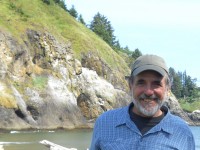
Ken is a prime example of how a citizen scientist—in this case, a master mapmaker—can change our perspective about the big issues impacting the Columbia River. Ken spent thirty-five years helping the U.S. Forest Service and the public understand resource management issues on federal forests. His philosophy has always been that better management decisions can be achieved through better understanding of natural resources and full disclosure to the public. Most useful to us, he spent two decades developing the digital mapping and analysis capabilities of the Forest Service using Geographic Information Systems (GIS).
In his retirement, Ken turned his attention and expertise to aiding the long-running fight to protect the Columbia River Estuary from LNG. In recent months, Ken spent hundreds of hours painstakingly compiling the publicly available information about Oregon LNG’s proposed route to help foster a deeper understanding of why the State of Oregon should reject the project.
We are grateful to Ken for devoting his time and talent. To check out Ken’s maps and appreciate what citizens across the Northwest saved from energy development, click here. Ken’s maps capture what words cannot: the dizzying scope of Oregon LNG’s impact and just how much the people of the Northwest achieved in stopping Oregon LNG.


